St. Thomas · USVI · 18.34°N 64.93°W

The VICARlab

The first Robotics and AI lab in the U.S. Caribbean, dedicated to marine science research and conservation.

In Progress This site is under active development. New content is being added regularly.

01 / About

A lab built for fast-changing ecosystems.

Diver above a bleached Caribbean reef during the 2023/2024 mass bleaching event
[Site name], U.S. Virgin Islands. Mass bleaching event, 2023/2024. Diver: [Diver name]. Photo: [Photographer].

The VICAR Lab is the research group behind the Virgin Islands Center for Autonomous Research, based at the Center for Marine and Environmental Studies (CMES) on St. Thomas. We build platforms that use autonomous underwater vehicles, 3D photogrammetry, and AI segmentation to study Caribbean reefs.

The lab launched in 2025 and is supported by a $7M NSF E-RISE RII award.

Our starting point is the Territorial Coral Reef Monitoring Program (TCRMP). TCRMP consists of 34 permanent monitoring reef sites across the U.S. Virgin Islands and 25 years of continuous reef survey data, including roughly 1.6 million expert point-count observations. We are bringing that archive into a modern, reproducible workflow, incorporating autonomous techniques strategically to incrementally improve data resolution and program efficiency.

VICARIUS (VICAR's Integrated Undersea Survey platform) is the integrated system behind this work, combining survey protocols, shared code, and the data pipelines that connect them. It is built to support research across multiple groups at CMES and to remain useful well beyond any single project.

We are recruiting master's students through the MMES program at CMES who want to work at the intersection of marine science, robotics, and machine learning.

↗ Read the launch announcement

02 / Projects

Active projects and preliminary tests.

Ongoing research using VICAR's platforms and methods, plus early-stage work on hardware, behavior, and field shakedowns.

Fish Spawning Aggregations · AUV + video

Grouper spawning aggregation monitoring

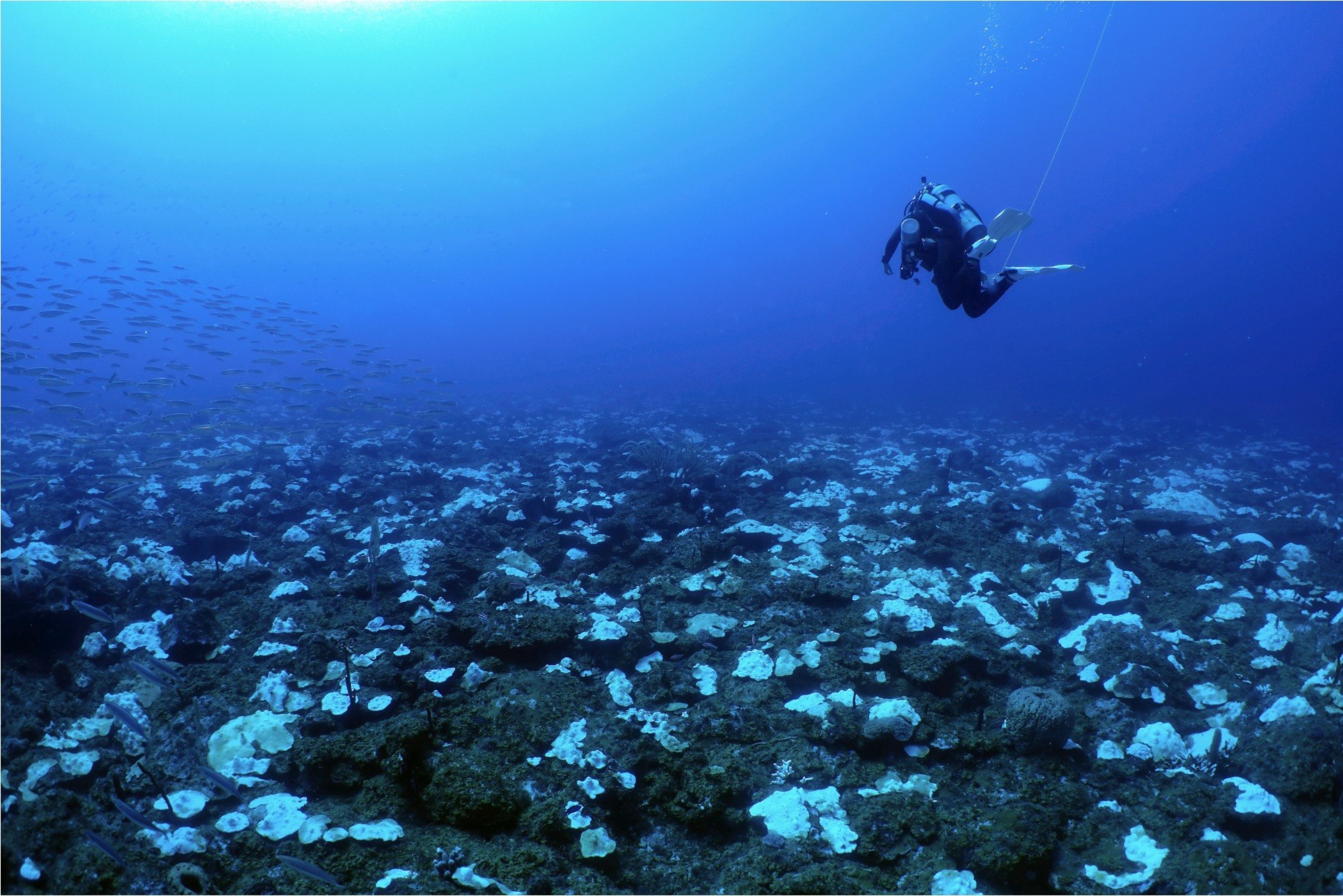
Caribbean groupers form predictable spawning aggregations (FSAs) at specific sites each winter. These aggregations are critical for population persistence and uniquely vulnerable to fishing pressure when fish concentrate in space and time. The lab is using underwater videography and emerging AUV-based survey methods to document FSAs as a non-extractive monitoring tool, building visual records of aggregation behavior and abundance that complement acoustic and diver-based approaches used across the U.S. Virgin Islands.

AI Fish Tracking · Computer Vision

AI tracking of fish from video

A computer-vision pipeline that detects and tracks individual fish across frames of underwater video. The same model can support automated abundance counts, species identification, and behavioral analysis. Applied to AUV transects and FSA footage, it offers a path to scaling fish-survey effort and to detecting previously undocumented spawning aggregations from existing video collections.

3D Photogrammetry · TCRMP

3D photogrammetric models of TCRMP sites

Diver-collected high-resolution imagery is reconstructed into dense 3D models of TCRMP reef sites, then used to track individual coral colonies through time. Madchen Gebhard is processing the 2025 annual TCRMP backlog across multiple sites, with AI-assisted annotation tools (TagLab) and 3D visual analytics platforms (VisCore) supporting colony-level identification, size and health change detection, structural complexity metrics, and competitive-interaction analysis across shallow and mesophotic habitats.

GCBE4 Response · Colony tracking

Tracking colony-level bleaching responses

Annotated 3D models of TCRMP sites are used to follow individual coral colonies through the 4th Global Coral Bleaching Event (2023 to 2024), the largest bleaching episode recorded in the U.S. Virgin Islands. Each colony is segmented, identified to species, and tracked across repeated visits, producing colony-level time series of size, tissue condition, mortality, and competitive interactions. The same models measure structural complexity at biologically meaningful scales, linking individual fate to habitat depth, exposure, and surrounding community composition.

AUV · Georeferenced DEMs

AUV imagery to centimeter-scale 3D maps

AUV-collected downward-facing imagery is reconstructed into georeferenced digital elevation models with centimeter-scale accuracy. The resulting orthomosaics and bathymetry layers drop directly into standard GIS workflows, where they can be overlaid on existing TCRMP spatial datasets, used to plan more precise follow-up AUV missions, and serve as a reusable substrate for ecological analysis.

Preliminary tests

AUV Methods · Hydrus microAUV

Hydrus microAUV deployment test

Early field tests of the lab's newest acquisition, the Hydrus microAUV from Advanced Navigation. The vehicle is small enough to be hand-deployed from a small boat (deployment is genuinely a flick of the wrist), which dramatically lowers the logistical bar for AUV-based reef survey work in the Virgin Islands.

Behavior Tests · RangerBot

Obstacle avoidance

Early test footage of a RangerBot AUV detecting and steering around a diver during a shallow-water transect at Reef Bay. The vehicle uses stereo vision and inertial sensing to detect obstacles in real time, a prerequisite for safe close-range survey work on complex reef terrain.

Hardware · BlueROV2

DVL installation and ROV repairs

Summer 2025 interns Gidal Williams and Viana Biscoe installing a Doppler Velocity Log (DVL) on the lab's BlueROV2. DVL integration gives the vehicle bottom-relative velocity measurements, supporting precise station keeping and georeferenced navigation during inspection and survey missions.

03 / Platforms

Our growing collection of intelligent machines and other tools.

Autonomous underwater vehicles for benthic and fish surveys (Hydrus, RangerBot), a diver-held Canon R5C cinema camera in a Nauticam underwater housing for 3D photogrammetry, and a Compute Core (BIZON workstation plus Synology NAS) for 3D reconstruction, AI model training, and archival storage.

04 / VICARIUS

VICAR's Integrated Undersea Survey platform.

The harness for everything the lab does more than once.

VICARIUS, short for VICAR's Integrated Undersea Survey platform, ties our repeated workflows together: AUV mission planning and post-mission processing, 3D photogrammetric reconstruction, AI model training and inference, segmentation and annotation review, classifier evaluation, and the data conventions that keep all of it traceable.

Treating these workflows as shared infrastructure (rather than one-off scripts inside individual projects) means a method developed for one student's thesis can be reused by the next, a model trained on one dataset can be applied to another, and results can be reproduced from raw inputs months or years later.

Code & repositories

05 / Outreach

Showing up locally.

Community events, tabling, classroom visits, and public talks the lab has been part of.

06 / Team

The people behind the work.

TCRMP team conducting reef surveys
Divers ascending from surveys at Cane Bay Deep, Spring 2026. Photo: J. Quetel

Faculty · Students · Collaborators.

VICAR Lab + CoRRL
07 / Field Notes

From the lab and the field.

Updates from the lab and the field: new deployments, student work, and progress against project milestones.